Friday, August 30, 2013

Pictured Rocks National Lakeshore


Our next stopping place was Munising, MI, jumping off place for the Pictured Rocks National Lakeshore. I just had to correct myself two times there and write Lakeshore instead of Seashore! These lakes are so large they look just like the ocean, ...hard to wrap my head around it all. The lighthouses don't make it any easier to remember. Anyway, I bought tickets for the sunset cruise (the most popular cruise because of the rosy glow of sunset) in eager anticipation of seeing the famous rocks from the water. I then made friends with a fellow selling fish sandwiches (Greg) down the way, found out what all to see before our cruise time, made a date for us to have dinner with him, and even got an invitation to park the rig for the night on a piece of his property down the road. You would be proud of how my friendship skills are developing!


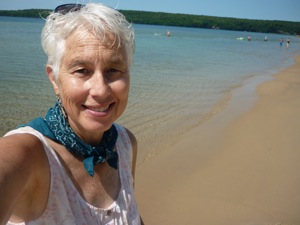
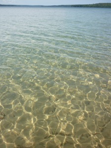
While I rode my bike around Thayer did his programming stuff for Chris, finding good internet right near the boat dock. I pedaled a few miles down to a waterfall and a perfect little beach on the bay called, fittingly enough, Sand Point. The sand was just like the finest golden brown sugar, without the sticky. The beach sloped out gently for about 100 feet before dropping into the lovely, clear blue green depths. There were a few people there but not many, and I really felt the need for Jackson to help me enjoy it all and to play with. I splashed around to cool off as the day was again pretty warm and sticky. I rode back to town, explored around a bit, found the thrift store and grocery store and just coasted around looking at the old buildings. 
P1090964P1090966
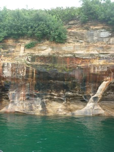
Later that afternoon we walked down to the fish shack, visited with Greg while he made our whitefish sandwiches and homemade fries (we brought the beer), then enjoyed our meal. Overlooking the fact that we always forget something, we headed down to the dock for the cruise. We and our approximately 80 new shipmates cruised by Grand Island and the old lighthouse on our way to the main event. Unfortunately, dead ahead, loomed a gloomy fog bank, sitting there like a big old wool blanket ready to tuck us in for the night. We were able to see a few of the fabulous pictured rocks before getting engulfed in the wooly interior of the fog. 
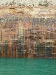
As the temperature dropped we realized what we had forgotten, Thayer's jacket. Being the tough old salt that he is, he did not whine or complain one little bit. It wasn't freezing fog anyway. Well, the short story is that the boat ended up turning around early and we received a full refund for our trip. But, as you can see, I did get a few good pictures and I'll bet you can't tell which ones I ripped off from Google images or our friend Anna Berger's blog. The color of the water was incredible, even in the fog.


P1090989P1100003 


P1100001


 For those of you who don't know, Anna and Emir Berger are the wonderful Australians we met a few years ago who inspired this year long adventure. Anna is a fantastic photographer and wrote up an amazing blog about their year and a half journey around the US with their delightful and beautiful daughters, Jordan and Bella.
P1090979

P1100005 


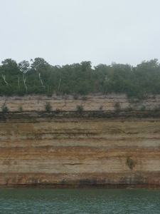
Now comes the educational geology part of the post so you may opt to quit reading now. These sandstone formations range in age from 1.1 billion y.o. (the dark red ones at the bottom) to 400-500 million y.o. (gray on top.) They were formed in ancient seas, wetlands and rivers. The top gray layer is harder than the others and has helped form these beautiful cliffs by protecting the softer layers underneath from erosion. The vertical streaking of black, brown, white, green and red is caused by minerals in water that flow between the layers of rock and drip down the cliffs. The most common minerals are iron, manganese and copper. The caves and arches are caused from the tremendous wave action of the great lake. I find it remarkable that the layers are still parallel to the water after a billion years, this must be a relatively stable part of the North American continent.
Oh, and by the way, these are all my photos. I didn't need to steal any!
P1050686

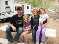
Those crazy Aussies, the Bergers! Thanks for getting us inspired!


Tuesday, August 27, 2013

Keweenaw Peninsula

P1090828
wetland flowers

We finished up PMWSP the next day, I went for a 5 mile hike through the woods while Thayer continued his computer work for his friend Chris.  He is setting up a website and working on product information and labeling.  It is an ongoing project that he seems to enjoy.  The woods were very beautiful, filled with maple, oak, cedar and many unfamiliar trees.  I imagined that this is what the eastern part of the US looked like when "A squirrel could go from the Atlantic to the Mississippi without touching the ground!"  I don't know who said that but I've heard it many times. It didn't take me long to do the hike, the bugs were very motivating!
P1090841
endless canopy of trees


P1090834
acorns from the mighty oaks


We then continued up the Keweenaw Peninsula, viewing the Eagle River Lighthouse and enjoying the lake views. Incredibly, we are just starting to see the fall colors coming out!  It appears that the sugar maples lead the way into fall, with their leaves just starting to turn on select branches. Just as it got dark we pulled into a cool wayside park on a little bay near Eagle Harbor.  It rained like crazy that night!


P1090855
Eagle River Lighthouse
P1090870
roadside pullout


The next day we drove just a little further up to the very top of Keweenaw to Fort Wilkens SP.  I am really beginning to appreciate the time, money and effort that has gone into the preservation of our historical treasures.  Here again is another beautifully preserved fort from the 1860's.  It was built to manage the rapidly growing trade and rowdy people that were coming to the area for copper, lumber, and mischief.  It wasn't used for very long, typical of boom and bust economies.  We toured the fort and bicycled around the park.
P1090875
blacksmith shop
P1090882
Ft. Wilkens SP
P1090884
general store


Now we headed back down the other side of the peninsula, the south side, taking in new sights and delights. We stopped at Brunette Beach and while Thayer dozed I walked up the beach to see the amazing rock formations. Sorry, here I go again! I'll try to be brief. This where all this sand is coming from!  Sedimentary rocks ranging in age from 1.5 Billion years to only 500 million years surround this lobe of Lake Superior. Needless to say glaciers, winter ice, monstrous winter waves, rivers and streams and wind have taken their toll on these soft layers of beautifully colored rocks. The lowest layers (1.5B), the Jacobville layers, are some of the oldest rocks you can see exposed in the US! They are the dark red rocks you see in the photos. Other subsequent layers are in gray, white and tan. We will visit these layers again when we go to Pictured Rock National Lakeshore.  But today I just moseyed along enjoying the interesting looping swirls of color along the shore. You will also see lots of lovely, rounded darker rocks that don't seem to fit in with all the others. These are glacial erratics transported here from the granite mountains of Canada. They come in all colors, textures, and sizes, most beautifully rounded and polished by the initial glacier transport and then by the pounding waves and swirling sand of the lake. There are also agates galore, their translucent colors just shine in the splash zone. I had to go back to the rig and convince Thayer to come have a look, boy, was he glad he did!

P1090898
Jacobville layer on the bottom 1.5 billion y.o.
P1090914
Canadian granite


P1090942
erratic amid the sandstone


Brunette Beach 8.2 miles north of Gay, MI

P1090950
agates

That night got a little tense as we drove into the darkness without a lot of turnouts for overnight. But Thayer rose to the occasion, found a forest service road,  and we settled in on a dead end. On the way in we had seen a large lightening storm brewing to the east. A few hours after we stopped it slowly rolled over us lighting up the sky with almost constant lightning for a good 45 minutes or so.  The lightning was high in the clouds so it wasn't too scary but it was simply an amazing light show! I've never seen anything like it! This was the hottest night yet, 90+ degrees, 90%humidity, with NO air movement, absolutely stifling!  One of the few hardships we must endure.


Monday, August 26, 2013

Prepare yourself for rock pictures...

I warned you, PMWSP has some pretty interesting rocks and geologic goings on!  It has the Nonsuch Shales near the bottom, metamorphosed sedimentary layers from vast old oceans in colors of black, gray, rust and pink. On top of the shales are the basalt layers laid down by a violent period of volcanic activity, all you northwesterners are familiar with that kind of action.  The massive weight of the basalt caused all kinds of tilting and sagging of the sedimentary and metamorphic layers. Then along came the glaciers to scrape and grind them down, pulverize them, and generally cause a lot of damage. At some point a LOT of lovely golden sand was created and used to decorate the shore of scenic Superior.

OK, with that possibly, sort of, accurate description, I'll tell you about our activities.  We spent one whole day walking up and down the Presque Isle River in the west corner of the park.  This small river spills down the watershed, carving its way over and through the Nonsuch Shales and patches of much softer sandstone.  The result is very beautiful and fun to explore.  


There are 3 or 4 larger falls where the river flows off of sharp edges of the shale. Most of the river is quite shallow as it spreads across the flat rocks.  The water itself is tinted brown and has a lot of foam, not because it is dirty, but because of organic matter in the soils that the water flows through.  The trails wind through the shady forest and there are frequent overlooks and places to go and wade around in the stream. This time of year it is warm and pleasant but I'm sure in the spring that river is a real rip snorter. They get a lot of snow here!  We found crawdads in the pools and some interesting invertebrate larvae that were attached, head down, to the rocks in the shallow riffles.  There were very circular holes drilled into the shale where rocks just ground the rock down during high water flow. 

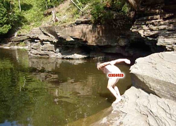
As the river flowed into Superior it formed a nice big pool just daring Thayer to skinny dip in. It looked inviting but I declined to join him and was glad I didn't because, shortly after he got in, a herd of young boys and their dippy mom/aunt came down to skip rocks for half an hour. Wouldn't want to traumatize any youngsters! 

The shales in this area were really interesting because they were petrified sand ripples and were broken in such a way that you could see that each layer had a different color, direction of ripples and texture. I hope my pictures will illustrate that for you.  See if you can match the picture to something I described...

After such a vigorous day of hiking and exploring we fell asleep in our chairs and read books on the beach until the sun did another glorious dive into the lake.  Found an empty trailer parking lot near a trailhead to spend the night.  We were the only ones there besides the owls that kept me awake for a while.
P1090722P1090755P1090748P1090767P1090779P1090778P1090733
P1090811P1090661P1090789x

Wednesday, August 21, 2013

Ashland and Boondocking and beyond


P1090643
Ice Cream at Buddies!
We stopped in Ashland, WI for a bike ride around the waterfront and town.  I love the riding, everything we've done is reasonably flat, we ride as long or short as we want, we see historic towns, lake views, and places we don't see from the rig.  The BEST part about this stop was BUDDIES, a little eatery on Main St.  A small cone ($2.50) consisted of more than a pint of good ice cream packed firmly down in a full size waffle cone. We each had one about 4:00 and really didn't need dinner.  One of those spectacular finds!

P1090652
Boondocking at Barb and Don's
A few months ago I had signed up with an organization called Boondocking.  For $30/year you get online access to 1000's of RVers who offer up a parking space on their property for free!  All you do is contact them via email a few days (or more) ahead of when you will be arriving.  If it is convenient for them, they give you the address and off you go!  We did our first boondocking in Park Falls, WI on Aug. 22.  I talked to Barb on the  phone, we drove there, backed into her driveway, plugged into their power and WIFI, chatted and went to bed.  They left early the next morning so we slept in, Thayer did some more work(!), and I rode my bike around town and did some thrift store shopping.  I have contacted a few other possible boondockers down the road, it is nice to have a place to stay and it's a fun way to meet people.  It's also a good way to get that valuable local knowledge. There are boondocker opportunities in every state (except ND, SD) and quite a few in Canada. 
P1090668
Lake of the Clouds- Porcupine Mtn. Wilderness SP
 After checking the tires and plumping them up, we actually did some driving and drove to Porcupine Mountains Wilderness State Park, located at the base of the Keweenaw Peninsula on Lake Superior.  We got there in the nick of time to check into the visitor center to buy an annual State Park Pass for Michigan.  Then we drove up   to the "Lake of the Clouds" overlook on the lake side of the park.  PMWSP is the largest state park in Michigan, it almost grew up to be a National Park.  It has a very interesting geology and I'll make you look at some rock pictures to prove it in my next post.  As evening came, we watched the sun set in a flaming puddle of light in the lake.  We found a nice pullout on the boundary road for the night, dang moon was so bright I had to wear my eyeshades.
sunset over Superior
happy campers

Tuesday, August 20, 2013

The Apostle Islands that weren't

P1090618
David and I cooling off, waiting for moonrise
Our next destination was the Apostle Islands, north and east of Duluth. They are a group of islands in Lake Superior that you really need a boat of some kind to explore.  We opted not to rent a boat or go on a cruise boats and come back to visit another time (yeah, right.). The ferry to Madeline Is seemed overly expensive as well.  We had a nice time in Bayfield though, its a cute little town with old homes, a large marina, interesting stores, and, my favorite, a community sailing program.  Just as we drove into town we saw the sign for a free concert in the park so we were happy.  We parked in the overflow ferry parking lot, right on the beach, and quickly made dinner.  We walked to the beach to eat and started visiting with a fellow who looked a LOT like my brother Robb.  He was in his swimming suit (bald, swimming suit – ring any bells?) and had his cameras  to photograph the full moon rising across the water, but didn't know where it would be coming up.  We all placed two sticks in the sand to line up where we were betting the moon would rise and sat back to wait. The music from the park wafted down to us as the sun set, and drinking a bottle of wine had nothing to do with any of this.
David, that was his name, is on a quest to swim in every river and near-to-the-edge lake of Lake Superior. It is a BIG lake, doncha know! It was very hot and muggy and David was enjoying the water so much that I put on my suit and joined him.  Because of the heavy humidity and haze it was not the spectacular moonrise he had hoped for, but it was fun watching it anyway.  A sailboat and airplane flew by at just the right moment for some great photos.  By the way, none of us were close in our moonrise location. Once we got the moon to its proper height we walked down to the park to finish up the music and then strolled the marina looking at the sailboats. There were many boats owned by folks who come for the weekend so it was pretty quiet. Chatted with the young Coast Guard cadets who were standing by to watch for drunk boaters.

P1090625
The next morning, while Thayer was working(!), I wandered the town, found a nice park with WIFI nearby, the smoked fish shop, the Maritime History Museum, and the North Coast Community Sailing Center. We moved the rig to the park and went swimming – really lovely water! Cooled off nicely before heading to our next destination. Unfortunately, there was no activity at the sailing center-would have been nice!
P1090639

Monday, August 19, 2013

Lake Superior and Duluth, MN

The rest of the plains went by, not much more description needed there. They were beautiful and we were lucky that they have had above normal rainfall, because they were very green, with many small lakes, interesting birds, and nice little towns. Thayer was eager to get into Duluth to pick up his mail consisting of the batteries and chargers for his camera that he left behind.  Thanks Sarah!


P1090594
Duluth is a cargo loading town! A huge part of their waterfront on Lake Superior is devoted to gigantic silos for loading grain from the plains, and amazing coal and ore loading areas. The harbor has a long spit (5 miles?) called Minnesota Point, that protects the inner harbor from the huge lake and the northers. The huge cargo ships come into the inner harbor around the end or through a arial bridge build over a hundred years ago by the Army Corps of Engineers.  


P1090593
On Minnesota Point are lovely and funky homes and a large park with bike trails, beaches, picnicking, volleyball and, best of all, a small community sailing center! The Duluth-Superior Sailing Association has a tiny toe hold on the edge of the park. They have about 8 Optis, 10 Lasers, and an assortment of small keel boats. Tim, the program director, was happy to chat with us about their program. They have two small sheds and a wire cage to keep their gear in. There were not a lot of people going out for such a beautiful day so he took us out in a Yingling (20ft keelboat.)  We had a lovely evening sail learning about the various features of the city, their little sailing program, and the lake. We were delighted to get out on the water away from the heat!


P1090577
Duluth industrial from Minn. Pt.
P1090560
Duluth Superior Sailing Assn.
The next morning we did a quick bike ride down the path and then headed into Duluth. We visited the Army Corps of Engineers Visitors Center where we learned about the history of trade and shipping in the Great Lakes, the arial bridge that controls traffic going to the loading docks, shipwrecks, engines, and all the cool boats used on the lakes. We were able to see a big freighter come through the canal, under the bridge and on to its docks. Nowadays, it takes only two workers to load a giant ship with ore, one on the boat to watch the loading and one above the ship controlling the conveyor belts that deliver the ore to the various hatches.  Two people can load 60,000 TONS of ore in 6-8 hours.
P1090588
bike path on Minnesota Pt.

Saturday, August 17, 2013

Across the Great Plains

We left our friends the Sorensons on Saturday the 17, bound for Theodore Roosevelt NP. It is a beautiful, rugged badlands area, where the rock formations have been eroded from the surrounding flatlands. The cliffs with their bands of colorful rocks, open green meadows and the Little Missouri River make for lovely views. We listened to a ranger (visualize William Macy in "Fargo") give a talk about the CCC projects in the park and the history of the CCC. Very interesting, though I kept wanting to finish his sentences for him since he spoke so slowly and sparingly. It was HOT. Thayer had me scampering along the road to take pictures of buffalo, funny how he would drive off just as the animals started staring at me and making huffing, grunting noises at me. Not funny. I tried to bring home a nice concretion to add to my rock collection but it just wouldn't budge and Thayer wouldn't help me.

I want this rock!

P1090451

We drove up to Lake Sacagawea St. Park for the night, beautiful and a little cooler. 
 
The next day we were up early and headed across the plains in a serious way. It is very flat, and very agricultural. When we got tired of looking at wheat we were refreshed by the sight of corn or sunflowers or an occasionally herd of cows. We pulled into tiny Sykeston, just for a fun photo with my namesake town. Ralph, from the cafe, quickly came out to greet us and invited us in for breakfast, home cooked and delicious, he assured me. We ordered up some eggs and carmel/cinnamon rolls as the locals started arriving after church. We met lots of nice people, including John and Rosemary, former Rialta owners and 15 years of RVing experience behind them. They are residents of Florida who "homestead" in ND during the summer. They were excited to see the rig and share their many stories. When I went to pay the bill John had already paid for our meal! It was a very fun stop! (wish I'd ordered another roll!) Turns out that the town cafe is supported by the "town fathers" because it is not profitable in any way. They support the cafe with funds and time. 


P1090542